|
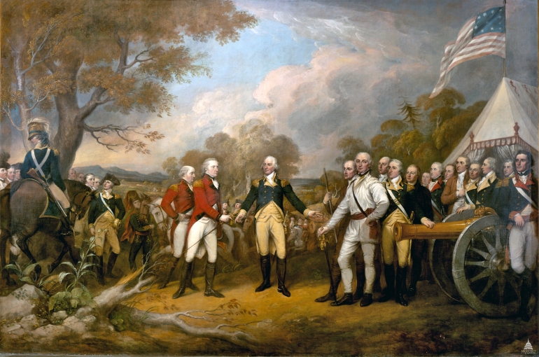
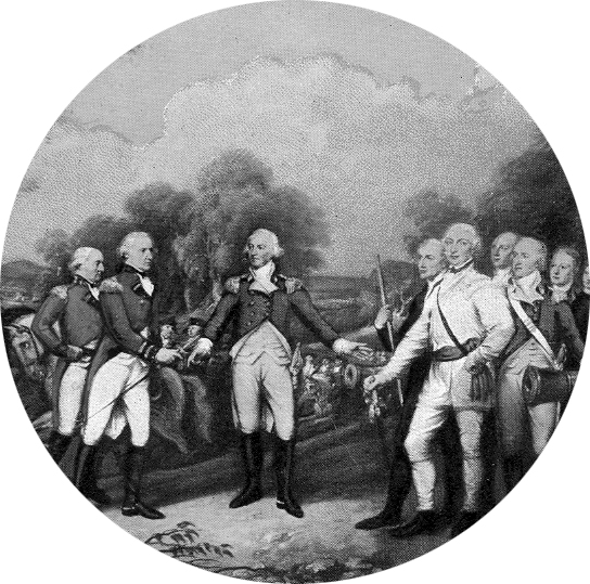
Burgoyne
Surrendering
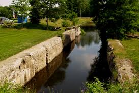
Champlain Canal
 |
Town of Saratoga Supervisors
1780-2015
Supervisors of Saratoga County
1878-1978
Supervisors of Saratoga County
1779-1877
History of the
Town of Saratoga
By Thomas N. Wood, III
The Town of
Saratoga has a legacy that is rich history and a
current environment that is attractive to
residential, commercial, and agricultural pursuits.
It is located in the eastern portion of Saratoga
County bordering the Hudson River on the East,
Saratoga Lake and the City of Saratoga Springs on
the West, the Town of Stillwater on the South, and
the Towns of Northumberland and Wilton on the North.
It was originally a district within Albany County
and subsequently in 1791 became one of the four
mother towns of Saratoga County. The first European
settlers arrived in the town in 1688.
Native Americans from the Mohawk branch of the
Iroquois inhabited the area over 12,000 years ago
and called the area Se-rach-ta-gue or Sa-ra-ta-ke.
It was a favorite area for the Native Americans
because of its excellent hunting and fishing and
because of the network of natural waterways. They
were able to easily travel north and south on the
Hudson River, east to Vermont on the Battenkill
River, and west on Fish Creek to Saratoga Lake, the
Kaderosseras, and ultimately the Mohawk River.
Dutch settlers were the first to obtain title to the
land and gave the name Sarachtoge to the gently
rolling land within a range of indefinite
boundaries. The region extended roughly from the
present-day Waterford to the state dam in
Northumberland and included land that stretched 6
miles along both sides of the Hudson River. As
early as 1684, a group that included Peter Schuyler
obtained the Saratoga Patent, the first title to the
land. Bartel Vroman became the first pioneer
settler in 1688. Officials at a convention held in
Albany on September 4, 1689, resolved that a fort be
made about the house of Bartel Vroman at Sarachtoge.
In the summer of 1690 , Schuyler who was then mayor
of Albany, cleared a spot in the forest, built a
blockhouse for his military stores, and named the
place Saratoga. In 1702 Johannes Schuyler settled
on the lands along Fish Creek, near the present
Village of Schuylerville. He established farms and
erected mills and other buildings as early as 1709.
As a way of drawing new people top the area,
Schuyler built a garrison house for protection from
raids of the French and Indian Wars. Together,
Schuyler and the Farmers and others who leased or
bought the land formed the first major
settlement, Fort Saratoga.
In spite of frequent raids, the settlement grew. By
the mid-1700s, it included some 30 dwellings with
granaries, pens, flour mills, stores, and blacksmith
shops, as well as the garrison. On November 17,
1745, a fierce attack destroyed Fort Saratoga.
Captain Peter Schuyler was killed in his own house.
Many others were also massacred or taken prisoner.
The settlement, including the garrison house was
burned. Fort Saratoga was rebuilt, but attacks
continued sporadically during the years of the
French and Indian Wars. In 1763, France and England
made peace, trouble subsided, and the settlement
revived. In 1767, Philip Schuyler erected a flax
mill, reported to be the first in the American
Colonies. In 1770 the Saratoga Reformed church was
organized.
As the country struggled for independence from the
British, Saratoga once again became a focal point of
warring activities. Both colonists and loyalists
maintained forts, camps, and headquarters within the
town. Philip Schuyler , the American General in
command, used his forces to delay the advance of the
British, led by General John Burgoyne. Hostilities
intensified in the summer of 1777. On September 10,
1777, Burgoyne's army enroute from Montreal to
Albany, crossed the Hudson River just north of
Schuylerville, halted for a short time and then
headed south. Near Bemis Heights Burgoyne's army,
considered the mightiest in the world at that time,
was defeated in the two battles at Saratoga on
September 19 and October 7. Burgoyne retreated back
to what is currently the Village of Schuylerville.
He became surrounded by the American forces and ten
days later, surrendered to Gen. Horatio Gates on
October 17. This surrender of British soldiers
marked the turning point of the American
Revolutionary War. It provided the impetus that
encouraged France to join the American cause against
the British, ultimately leading to the Americans
winning the Revolutionary War.
Saratoga suffered throughout the war. Many of the
residents lost their lives while others suffered
great damage to their property. Gradually, in the
years following the war, the town began to grow and
prosper. Flour mills, linen mills, paper mills, and
saw mills were constructed. Schools, churches, and
businesses were established. The two highways that
passed through the town , the old Montreal and
Albany military road and the Saratoga springs to
Boston Road were improved.
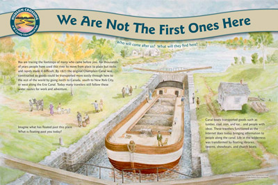
The completion of the Champlain Canal in 1822
provided a great impetus to growth. The Champlain
Canal passed through the town from North to South A
boat basin and dry dock were developed in
Schuylerville, and the town became a major shipping
terminal on the canal. Boatloads of potatoes,
grain, lumber, hay, and paper originated here. A
mule barn was built to house more than 100 mules.
As the demand increased, numerous warehouses,
hotels, blacksmith shops, and businesses were
established. Today portions of old tow path have
been cleared and maintained as a pleasant walking
path with numerous illustrated sign boards
describing the history of the canal.
In 1882 the Fitchburg Railroad passed through the
town connecting Saratoga (Schuylerville) to Saratoga
Springs and Mechanicville and Troy. This Railroad
eventually became a part of the Boston and Maine and
eventually the Saratoga and Schuylerville Railroad
which was abandoned in 1956. The Hudson Valley
Railroad followed in 1899 providing electric
trolley service connecting Schuylerville with Troy
to the south and Glens Falls to the north. With the
increased use of automobiles, the trolley fell on
hard times and was abandoned in 1929.
Over the years the Town of Saratoga underwent many
boundary adjustments. The original town was much
larger and was a part of Albany county. In 1772,
the state divided what is now Saratoga County into
two districts: Halfmoon and Saraghtoga, which
included the present day town of Easton in
Washington county. Three years later, the state
took part of Saraghtoga and made it into a third
district, called Ballstown. The New York State
legislature passed an act in 1788 creating towns in
place of districts, and from Saratoga took a
portion, including Malta, that became the town of
Stillwater. The Town of Saratoga was still much
larger than it is today. It included all or parts
of what in years to come were separated as the towns
of Northumberland, Moreau, Wilton, Saratoga Springs,
plus parts of the current towns of Greenfield, and
Corinth. In 1791, Saratoga County was established
and all of the towns in Albany County north of the
Mohawk River became a part of Saratoga County. Since
1819 the boundaries of the town of Saratoga have
remained the same.
During the first half of the 19th
century, two villages were incorporated within the
town of Saratoga: Schuylerville, named after the
Schuyler family, who were responsible for developing
the area in 1831; and Victory - named - as were its
mills- in recognition of the American victory during
the battles of Saratoga in 1848. Hamlets with the
names of Coveville, Quaker Springs, Grangerville,
and Deans Corners, also developed within the Town of
Saratoga.
In the 19th and 20th centuries
Agriculture flourished in the rich, fertile fields
of Saratoga. Mills thrived as a result of the
abundant water power and good transportation.
Life was good in the town. Many patriotic
residents served their country in the Civil War,
World War I, World War II, the Korean War and the
Vietnam War. Many historic areas, markers, and
monuments, including the Saratoga National Historic
Park and the Saratoga Monument, were created to
preserve, protect, honor and commemorate the
American victory and the brave service and
accomplishments of the areas residents. In the
late 1990s the federal government established the
new Saratoga National Cemetery in the Town of
Saratoga. Veterans from all over upstate New
York are now being buried in their final resting
place overlooking the Hudson River Valley and the
place where freedom and
independence were won for America.
Since the mid 20th century there has been
a gradual reduction in the number of farms in the
town. Agriculture is still an important part of the
local economy, but as a result of technology, it is
more efficient and fewer people and less land are
required to produce more products and crops. Today
several large dairy, horse, fruit, and vegetable
farms operate within the town. Their presence
provides a peaceful and appealing setting for
numerous residential developments. Horse farming
has increased with a large number of champion
thoroughbred and standardbred horses now being bred
and raised in the town.
Agri-tourism is expanding with corn mazes, hay
rides, and pick your own apples and produce. Most
of the mills that thrived in earlier years have gone
out of business taking with them numerous jobs.
With better roads and safer cars, housing
developments are growing and more people are living
within the town and commuting to jobs located in the
capital district area. The quality of life that the
town has to offer is attracting more and more
people. Recreational opportunities are expanding
using former resources and attributes such as the
old Champlain Canal tow path, the Hudson River, the
Sword Surrender Site, and the Victory Woods.
Recreational Parks such as Schuyler Park are being
established to meet the recreational needs of all of
our residents.
Over the years the Town of Saratoga has undergone
many changes. Today a comprehensive land use plan
is in place encouraging a controlled growth and
development of the area. In 2008 the town purchased
the old high school at 12 Spring Street in
Schuylerville and conducts all town business from
this office location. A new 29 acre Town Park,
Schuyler Park located on Route 29, 4 miles west
of Schuylerville, is home to many athletic and
community events. Boat launches in Schuylerville,
on Route 4 South of Schuylerville, and on Saratoga
Lake provide recreational water access for visitors
and residents. Schuyler Yacht Basin, a commercial
marina is located in Schuylerville and other
commercial marinas are located on Fish Creek and
Saratoga Lake. A portion of the Hudson Crossing Park
located just north of Schuylerville is located
within the town of Saratoga. A new town highway
department garage complex is located near the middle
of town on route 32 south. New hiking trails have
been completed on Wilbur road, the old canal
towpath in Schuylerville and the Victory Woods trail
near the Saratoga Monument. The National park
Service owns and manages the Schuyler House and the
Saratoga Monument. The Town is also the site of the
Saratoga National Cemetery and The Saratoga County
Veterans Memorial. This peaceful and serene setting
with great views of the Hudson River valley provides
an ideal location to reflect on the service and
dedication of our veterans.
Other places of historical importance include the
Marshall House, the Sword Surrender Site, and Fort
Hardy Park. A new Gateway Regional Visitors Center
operated by the Historic Hudson Hoosic Partnership
is being planned for the old town hall site on Ferry
Street in Schuylerville. Despite all of the changes
that have occurred, the rural character of the Town
and the spirit of the residents has remained
constant. As the new millennium unfolds the town is
prepared to honor its past and welcome the
challenges that are forthcoming in the future.
|
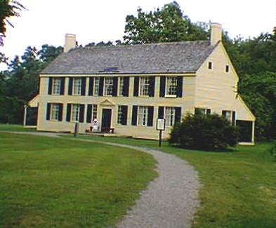
Schuyler House
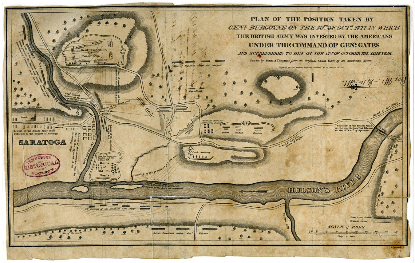
Battle of
Saratoga Map
|